INFORMATION ON THE CITY
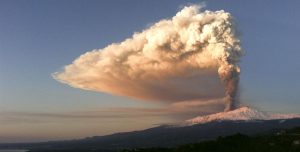
 Catania offers heterogeneous landscapes concentrated in a restricted area. It stands on the east coast of the island, at the foot of Etna (the highest active volcano in Europe) about halfway between the cities of Messina and Syracuse, overlooking the Ionian Sea with the gulf that takes its name from it.
The territory is mainly flat to the south and south-east, and mountainous to the north due to the presence of Etna. It also includes a substantial part of the plain of Catania (‘a Chiana), one of the largest cultivated areas of Sicily, whose area closest to the sea is the Oasis of Simeto, a natural reserve of about 2,000 hectares, established in 1984 The Simeto oasis takes its name from the Simeto river that flows south of the town, in the Primosole hamlet.
 The original nucleus of the city was located on a hill: the hill of Monte Vergine (49 m asl), born from a prehistoric eruption of Etna dated between 15,000 and 3960 ± 60 years from the present, corresponding to today’s Piazza Dante Alighieri where stands the Monastery of San Nicolò l’Arena (now a university), near which flowed a stream, the Amenano, which flowed near the current Piazza del Duomo, while to the south there was the terrace of Acquicella (15 m asl), separated from the river by a valley, then filled by the lava of the 1669 eruption. The only other important relief is the Santa Sofia hill (303 m asl), in the homonymous district, where the University Citadel rises , almost on the border with Gravina di Catania, a town in the vast hinterland.
The public green consists of the parks located within the city. There are six of a certain size and importance: the Giardino Bellini or Villa Bellini, called ‘a Villa, is dedicated to the musician Vincenzo Bellini; the Pacini Garden or Villa Pacini, nicknamed Villa ‘e varagghi (ie “degli sbadigli”) dedicated to the musician Giovanni Pacini; the Gioeni Park (located north of the Borgo district, at the end of Via Etnea); the Falcone e Borsellino Park (north of Corso Italia), dedicated to the homonyms magistrates killed by the mafia; and the Boschetto della Plaia (in the area between the south of the city and the Vincenzo Bellini Airport, the former Municipal Fruit and Vegetable Market and the Plaia district). Among other things, due to the historical importance and the conservation of biodiversity, the Botanical Garden of Catania, in the Mercede district, should be mentioned.
 The city is crossed by an underground river, the aforementioned Amenano, which once flowed where today is the aforementioned Villa Pacini and now flows more to the south-east, where there is the port. It is visible at the Fountain of the Amanano, a fountain in white marble called by the Catanesi the Acqua a ‘llinzolu which rises between the so-called “Pescheria” and the Piazza del Duomo, and in the basement of the local Ostello Agorà. In the past, just outside the walls to the west, you could find the lake of Nicito, connected to the river and now covered by the lava flow of 1669 (the homonymous street reminds its location).
But it was the surrounding area that changed profoundly as a result of natural disasters such as the various lava flows: the north coast of the port consists of a cliff, located where today is the Central Station, called the Armìsi and formed in various historical eras in 1169, 1329 and 1381, the year in which part of the ancient Porto Ulisse was also covered in the Ognina district; this stretch of coast includes the beach of San Giovanni li Cuti. The area south of the Ursino Castle, once on the sea, is instead the product of the enormous 1669 casting which, as it was ringing, pushed for a few kilometers towards the gulf. The coast south of the port was deeply modified, starting south of the Plaia sandy coastline further south.